


The Manly Heritage Plaques Walk
Heritage Plaques in Manly ©2002 Manly Council Marine Parade 1920s: Courtesy Manly Art Gallery & Museum, Acknowledgements: Katherine Roberts & Christopher Parsons Map drawn by Renée Ezz. Photographs courtesy Manly Library & Manly Art Gallery and Museum. Produced by Manly Council’s Heritage Committee, 2002
1. The Aboriginal Heritage of Manly East Esplanade Reserve
This plaque acknowledges that Australia's Indigenous Peoples, in particular the Cannalgal and Kayimai clans, were the custodians of this area long before it came to be known as Manly. The Cannalgal and Kayimai people were custodians of the land, and all the sacred and secret sacred sites that were bequeathed to them by Baiame, the all powerful being who created men and women and their world.
Aboriginal culture is rich and varied; it is a proud and intrinsic part of Australia's heritage. To all Aboriginal peoples, the Earth is the mother of all things. It is therefore the base of the kinship system which binds all people, plants, animals, birds, land and water into one huge family. The image on the plaque represents this relationship.
The moon, the stars and the hands are in balance with Mother Earth, represented by the large circle; together they tell a story of caring and sharing. The contour lines reflect the foreshore and the landscape of Manly. The hands represent the family and unity. The large hands are those of the elders, whose wisdom is all important, the smaller hands represent children, our future. The plaque was unveiled on the 3 July 1994 by Lowjita (Lois) O'Donoghue CBE AM, Chairperson, The Aboriginal & Torres Strait Islander Commission.
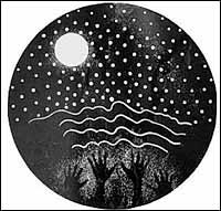
Artwork by Mini Heath, 1994. Courtesy: The artist.
Top | Walks Menu | Visitor Info Menu
2. Manly Cove ~ 1856 ~ Manly Cove near Manly Wharf
This is how Manly looked in 1856 when S.T. Gill sketched an unnamed paddle-wheel steamer approaching the first pier and the Pier Hotel. Manly was very isolated. It took about two hours to travel from Sydney by land, crossing Sydney Harbour at Dawes Point and the Spit by punts. By 1854 Sydney Harbour was experiencing an excursion boom. On Boxing Day the paddle-steamer Nora Creina cruised to Manly, landing at "a spot surpassing all others in the harbour of Sydney."
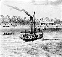 S.T. Gill, Manly, 1856As there was no wharf then, passengers probably went ashore by boat or landed at North Harbour Wharf. Henry Gilbert Smith, 'The Father of Manly', showed remarkable foresight when he first purchased land in 1853 to develop his 'Brighton of the South', where people could enjoy fresh sea air and escape from the dirt and noise of the city. By the end of 1855 he had built the first Manly Wharf, initiated a ferry service to bring day-trippers to his resort and built the Pier Hotel for more leisurely visitors. The historian, C.H. Bertie wrote: "Today the reserves on the ocean and harbour frontages and the parks, are ... the result of this worthy man."
S.T. Gill, Manly, 1856
Photograph courtesy: Manly Art Gallery & Museum
Henry Gilbert Smith (1802-1886) 'The Father of Manly'
Until the mid 1850s, Manly was undeveloped bushland. It was an Englishman, Henry Gilbert Smith, who saw its potential as a seaside resort. He wrote to his family in 1853: "Its situation, 7 or 8 miles from Sydney by water, is as fine a thing as you can imagine and it takes in the only ground which has the sea beach on one side and a fine sandy cove on the other..." He purchased and leased over 300 acres of land and planned the streets and parks much as they are today. 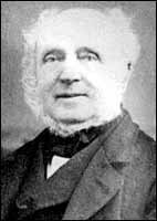 Henry SmithHe named his project Ellensville, after his first wife, but later changed it to Brighton, suggesting to holidaying New South Wales residents, most of whom were British, that time spent here would be as good as a holiday at Brighton, one of England's finest holiday resorts.
The name Manly was officially adopted when Council was constituted in 1877. Born in Northhamptonshire, England, he came to Sydney in 1827, aged 25, and established an import and export agency with his brother Thomas. Over the next 39 years he lived alternately in New South Wales and England, successfully fostering his commercial enterprises, including the first steamship built in Australia, The Surprise, in 1830. Although he was a man of extensive business interests, he entered the NSW Parliament as a member of the Upper House in 1856. Henry Gilbert Smith's words written in 1856, express his vision and love for Manly:
".. there is no spot to equal it in beauty. It is truly delightful ... there is nothing like it that I have seen in the widewide world."
Top | Walks Menu | Visitor Info Menu
3. The Corso ~ 1920s
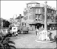 The Corso 1920.The Corso, outside Coles From the Corso we look along Whistler Street, named after Henry Gilbert Smith's first wife's family. The former Town Hall, once the imposing residence of Mr W.H. Rolfe, stands on one corner and the building advertising 'Cold Luncheons' still stands today. Henry Gilbert Smith promoted Manly as a 'watering place' in the 1850s, but development was slow. It was not until 1877 that the first meeting of Manly Municipal Council was held in the Church of England school room. Council then met in several different locations in Manly, including the old Ivanhoe Park Hotel building in Ivanhoe Park until 1909 when it purchased Mr Rolfe's old home. This was demolished in 1937 and the present Town Hall was erected. The vehicles are early privately owned buses which began running to Queenscliff and Freshwater around 1920. The palm tree in the foreground now towers above the Corso. The Soldiers' Memorial was erected in 1916 in memory of the first soldier from Manly to fall in World War One. The carved dolphins on its base signify that the casualties came from the seaside, while the Waratahs and Christmas Bells on the capital illustrate how Manly was once famous for its wildflowers.
Photograph courtesy: Manly Library
4. The Corso ~ 1915
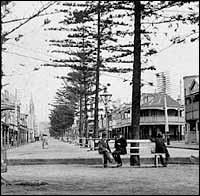 The Corso 1915The Corso, beach end, Manly In a peaceful atmosphere, old men sit yarning while boys ride bicycles, at a time when many young men were away fighting in World War One. With only one car visible, The Corso resembles the paved mall of today but without the bustling throng or traffic lights. Manly's first street lights were kerosene lamps, then gaslights from 1884, which were replaced by electric street lighting in 1923. The pines planted under Council's 'beautification scheme' have been replaced by palms. The refreshment rooms on the left have lost their original awnings and fancy posts. Further along the Corso, the elegant spire of the first St Matthews Church of England, designed by Edmund Blacket and opened in 1865, can be seen. It was demolished in 1928 and the present church, built on an adjacent site, was opened two years later. The original Steyne Hotel was built by Henry Gilbert Smith in 1859 when The Corso was only a sand track, and the New Brighton Hotel pictured here was constructed in 1880. The hotels have been rebuilt over the years, providing a continuous supply of refreshment and places of rest for visitors to Manly.
Photograph courtesy: Manly Art Gallery & Museum
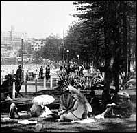
5. Marine Parade ~ 1920s
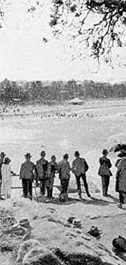
Marine Parade overlooking Manly Beach From this lookout, formally attired spectators watch a surf carnival against a sweeping panorama of thriving pines. Today high-rise buildings dwarf the trees, which were damaged by airborne pollution from North Head sewerage works. Since the construction of the deepwater ocean outfall, Manly Council has undertaken an extensive replanting and rehabilitation scheme to restore the beauty of this heritage-listed beach. In 1898, the promenade to Fairy Bower was constructed above the sewer line to Cabbage Tree Bay. Originally, Manly Beach was known as Cabbage Tree Beach because of the many cabbage tree palms growing in the area. The surf lifesaving movement holds huge significance in Manly's history. After daylight bathing became legal and crowds flocked to Manly's beaches, not everybody understood the dangers of the surf. The Sly brothers were the first lifesavers to patrol the beaches in their boat. In 1903 they staged a lifesaving demonstration on Manly Beach to raise money for this essential service. Early surf carnivals like this attracted thousands of visitors.
Top | Walks Menu | Visitor Info Menu
6. South Steyne ~ c.1929
 South Steyne 1929North Steyne near Carlton Street Along South Steyne, holiday-makers shelter in shady gardens beneath Norfolk Island pines. Soon after Manly Municipal Council was incorporated in 1877, it began a tree-planting scheme resulting in this magnificent crescent of pines that has made Manly internationally famous. The style of clothing, women wearing hats and carrying parasols, and men attired in suits, waistcoats and felt hats, contrasts with today's casual dress. The Manly Life Saving Club building pictured at the southern end of the beach was built in 1914 and extended in 1923. These premises have been rebuilt over the years to cater for the ever-increasing popularity of surfing. The earliest portion of the seawall was constructed along South Steyne in the late 1880s. For ease of walking for those 'taking the air' along the promenade, asphalt paths were laid in 1902. The gracious guest houses of this period have been demolished and replaced by blocks of flats. Impressive St Patrick's Seminary, opened in 1889, was the first Roman Catholic training college built in Australia.
Photograph courtesy: Manly Art Gallery & Museum
7. Ivanhoe Park ~ c.1930
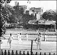 Ivanhoe ParkCorner Sydney & Pittwater Roads Men dressed in white flannels play tennis at Ivanhoe Park which was purchased by the NSW Government in the early 1880s for £8,600. It has since remained a sportsground and over the years a wide range of sport has been played here, including croquet. The Merrett Memorial Gateway was erected in memory of Manly sportsman, O.G.H. Merrett, manager of the Australian team attending the 1924 Paris Olympic Games at which local heroes, 'Boy' Charlton, Dick Eve and 'Nick' Winter won gold medals. In the background towers Dalley's Castle, home of William Bede Dalley. First named Marinella, it was built of local sandstone during the 1880s, a period of grandiose buildings such as St Patrick's Seminary and Clavering (now Dalwood). In 1939 Dalley's Castle was demolished with virtually no protest and replaced by blocks of flats. Now only two gargoyles, one a dragon and the other a hunting dog, stand guard above the old stone wall in Sydney Road. Son of former convicts, William Dalley became NSW Attorney-General and, in 1885, served as Acting Premier.
Photograph courtesy: Manly Art Gallery & Museum
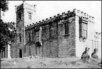
8. Fairlight House
 Fairlight HouseFairlight Beach on Scenic Foreshore Walkway The stone wall and pine trees are all that remain to remind us of Fairlight House, the home of Henry Gilbert Smith (1802-1886). He first saw the potential of Manly as a seaside resort and laid out central Manly much as it is today. He commissioned the eminent Colonial architect, Edmund Thomas Blacket, and local builder Alexander Dean, to design and build Fairlight House. Erected in local sandstone, it was of classic rectangular Georgian design, two storeys high, five windows and ten shutters wide. The ground floor of the house had verandahs on the front and one side. The name 'Fairlight' had strong emotional ties for Smith. It was the name of the village in Sussex, England, where his first wife, Eleanor Whistler had once lived. The house was first occupied around 1860. The 36 acres (15 hectares) estate stood just behind the pine trees, extending half a kilometre northwards to Hilltop Crescent. Smith's second wife, Anne Margaret, died of tuberculosis in April 1866 and is buried in Manly Cemetery. The family enjoyed Fairlight House for only six years, after which the family left for England. The tower and portico in the photograph were added by subsequent owners. The house was demolished in 1939. There was a 100 foot reservation dedicated to public recreation on the harbour foreshore of the estate's southern boundary.
Photograph courtesy: Manly, Warringah & Pittwater Historical Society
Top | Walks Menu | Visitor Info Menu
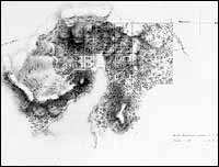 North Harbour Reserve
Historically, this area is one of the oldest parts of Manly, dating back to the arrival of the First Fleet in 1788. Manly derives its name from Captain Arthur Phillip's description of the 'manly natives' that greeted him, and a subsequent map by Captain John Hunter placed Manly Cove off North Harbour reserve. Surveyor John Oxley noted in 1827 that the land in North Harbour had "long been pointed out as a proper situation to be reserved for the site of a village". It was particularly attractive because three fresh water streams could supply the potential village and one of them, the waterfall flowing beneath the bridge at Gourlay Avenue, can still be seen. The village was laid out in 1828 but the area had attracted settlement well before then. The map below shows a small hut once occupied by John Fincham who had arrived with the Third Fleet in 1791, and he was subsequently granted Lot 19 in the Village. Improved roads and reliable motor transport in the 1920s contributed significantly to the changes that turned the Village of North Harbour into the suburb of Balgowlah. In 1938 the large sandy bay which had originally extended to Condamine Street was reclaimed and made into the present park.
Courtesy: Mitchell Library, State Library of NSW
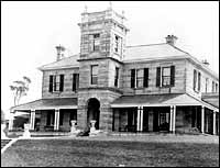
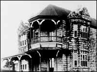
10. Dalley's Castle
 Dalley's CastleIn Gilbert Park near Tower Street An imposing residence called Marinella, or place by the sea, more popularly known as Dalley's Castle, once occupied the site of the flats opposite the position of this plaque. William Bede Dalley (1831-1888) has a statue in Hyde Park and memorials in St Mary's Cathedral, Sydney and St Paul's Cathedral, London dedicated to him. He was born in Sydney of an English Protestant father and Irish Catholic mother, both ex-convicts. His intellect and powerful oratory were noticed by his mentor, Archbishop Polding, who encouraged him to enter journalism, law and politics. He became NSW Attorney-General and in 1885 served as Acting Premier.
Photographer Leon Cayley Courtesy: Manly Library
Dalley had a passion for grand homes. He built the mansion Clairvaux, overlooking Rose Bay, with its great view of Sydney Harbour. He sold it immediately after his wife's early death on 17 January 1881, which left him with five young children under eight years old. He bought the site opposite on 15 December 1882 erecting the building shown in the photograph. Despite its imposing appearance, other photographs taken at the rear suggest that it was only partially completed. He owned the property for a mere five and a half years. Dogged by sickness he sold it in 1888 and died five months later in Sydney, at the relatively young age of 57. His funeral was attended by 6000 people and among the floral tributes was a wreath of flannel flowers collected at Manly and presented by the Municipality. Dalley's Castle was owned by the McGaw family for many years and then in the 1930s it became the Camden Grammar School. It was eventually demolished in 1939. Part of the land was acquired by the Housing Commission, and the flats Marinella were erected and opened by the Minister for Housing, Clive Evatt, on the 3rd of June 1950.
Top | Walks Menu | Visitor Info Menu
Dalley Park
(On reverse of 'Dalley's Castle' plaque)
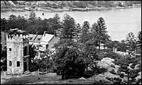 Dalley's ParkThe original name of Dalley Park was Tower Hill Park, a name that is still used on formal land records. This older name goes back to Manly's earliest beginnings when Henry Gilbert Smith laid out Manly much as it is today. Several parks and open spaces were incorporated into the design. An 1855 plan shows this area as Tower Hill Park with a tower marked thereon. This tower was in fact a Camera Obscura. This was a novelty of the time where, in a darkened room, optical images of the surrounding countryside were projected on to a screen. The above photograph of the tower was taken shortly before its demolition and does not show the original dome that housed the viewing lens. Manly Council was constituted in 1877 and in 1879 H.G. Smith generously donated many of Manly's parks and open spaces to Manly Council including this park. A small parcel of land embracing the tower and adjacent cottage was excised from the park and sold by H.G. Smith in 1878. For some years this was part of the Dalley's Castle estate, but was eventually bought by Council in 1920 and is now incorporated in the park.
Photograph by Frank Bell Courtesy: Manly Art Gallery & Museum
11. Queenscliff Bridge
 QueenscliffNorth Steyne, near the bridge
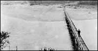
Manly Lagoon, described on the reverse of this plaque, forms the northern boundary of the Manly local government area. It could only be crossed at the entrance at low tide. In 1885 a footbridge was constructed across the lagoon entrance by real estate developers which facilitated land sales in the Queenscliff area by improving access to Manly. The lagoon then was extensive and there were few houses in the vicinity. The words of Francis Myers author of Beautiful Manly reveal this.
Photograph courtesy: Manly Art Gallery & Museum
He recommended stopping on the bridge to admire the view. He said: It is most divine on an afternoon with the sun well down the hills, and a silvery light upon all the broad water. The wet rocks then upon the Queenscliff side glisten through all their gleaming leaves, and there is a glory upon the pines that clothe the little convent hill, and far up the flat the light sprays of the oaks are as feathers of gold above the swart growth of 17 scrub and ti-tree. With a sufficient light through their shadowy depths the forest-bearing hills shut the picture in. The convent hill mentioned above was the Star of the Sea Convent which was located on a property purchased by the Sisters of the Good Samaritan Order in 1881. The land extended along the banks of Manly Lagoon and from the ocean front to Pittwater Road. Much of the land was later subdivided and sold. The original stone house was replaced in 1931 and the name of the school latinised to Stella Maris. In 1918 Manly and Warringah Councils replaced the footbridge with a vehicular bridge which was widened in the 1930s and eventually replaced with the present one in 1990.
11. Manly Lagoon
(On reverse of 'Queenscliff Bridge' plaque)
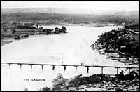 Manly LagoonEarly maps name this area Curl Curl Lagoon but the name was later changed to Manly Lagoon. Manly Lagoon is fed by a large catchment area including the areas of Warringah Mall and Manly Dam. Much of this area was marshy wetlands. A large part of the low lying land has been reclaimed particularly in the 1920s by Mr A.T. Keirle, a one time Mayor of Manly, after whom Keirle Park is named. The areas reclaimed also include Manly Golf Course, Lagoon Park, Hinkler Park, Warringah Golf Course (south of Kentwell Road) and Nolan Reserve. Market gardens sprang up along the creeks which fed into the lagoon at Manly Vale and Brookvale. Hinkler Park was originally an island and the lagoon flowed either side of it. In the 1950s, the southern flow was infilled as part of roadworks to accommodate Pittwater Road. Urban growth has resulted in increased pollution of the lagoon. This problem is being addressed jointly by Manly and Warringah Councils.
Photograph courtesy: Manly Library
Top | Walks Menu | Visitor Info Menu
12. The Jenkins Road
King Avenue
This plaque overlooks the southern end of the early road from North Harbour, Balgowlah, to Long Reef, Collaroy. Even today Condamine Street, Old Pittwater Road and Pittwater Road mark much of the old route. The road and its thirteen bridges were built in 1826 by James Jenkins (1776-1835) at a personal cost of £300. He needed the road to transport produce from his Long Reef farm to North Harbour for the water crossing to Sydney's markets. On shore below this plaque, Jenkins built a small stone house and a landing place for his boat. The choice of this location was no doubt influenced by the presence of a constant flowing stream. When he petitioned Governor Darling for this land in March 1827 he reported that he needed these facilities because leaving his horse tied to a tree, its harness secreted in the bush, and his cart out in the open, meant that "any malicious or felonious person" could steal them. He worried, too, about his boat and its usefulness to "every fugitive convict or other evil disposed persons." Jenkins himself, was a convict who arrived in Sydney on the Coromandel in 1802. In the space of a few years he established himself in boat building, stonemasonry and farming. He lived with his family in Kent Street, Sydney, and owned 1740 acres (704 hectares) of land extending from Mona Vale to Dee Why and 2½ acres at North Harbour. A substantial part of the Jenkins estate was given to the Salvation Army by his daughter Elizabeth who died in 1900. When King Avenue was built in 1920, the site of Jenkins's stone house became 3 King Avenue.
13. Bridging the Spit
Spit Bridge, Avona Crescent
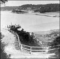 The SpitAs early as 1829, there was a rowing boat service to ferry passengers across Middle Harbour. In about 1850, Peter Ellery began a hand operated punt service. This proved inadequate and in 1888-89, proposals for a low level bridge at The Spit which could be opened for yachts was submitted by the Parliamentary Standing Committee on Public Works to the Legislative Assembly. Plans were also prepared for a steam punt designed to carry eight ordinary sized buggies in one trip with a crew of two. It was planned that this punt would operate until the bridge was completed and then be removed to another site. A high level bridge to take a railway line across Middle Harbour was also proposed at the time.
Photograph courtesy: Manly Art Gallery & Museum
The steam punt, introduced in 1889 became a reality. The low level bridge was to follow 35 years later. The high level bridge and railway to this day have not eventuated. Public demand for a tram service to connect Manly to North Sydney via The Spit resulted in a Spit to Manly service being established in 1911. Passengers coming from North Sydney on the tram service had to alight at the Mosman side of The Spit, transfer to the punt on foot, then join another tram for the trip to Manly. Although the punt 'bridged' The Spit, it was a drawnout journey and unpleasant in inclement weather. In 1922 Manly Municipal Council Alderman A.A. Kemp proposed that Manly and Mosman Councils in conjunction with the Tramways Department build a low level bridge with tolls levied to pay for it. The most favoured design would carry two lines of tramway and cost £150,000. Timber was to be used in the construction of what was intended to be a temporary structure. However, the bridge actually built was without the tramlines and cost about £70,000. The bridge was opened on 23rd December 1924 by Premier Sir George Fuller. The toll ceased in March 1930 and from that date the bridge was maintained, managed and administered by the NSW Public Works Department With the completion of the Sydney Harbour Bridge, the land north of Middle Harbour was becoming more closely settled, the Spit Bridge could no longer cope with the volume of traffic using it. A new bridge was needed, but the outbreak of World War II delayed its construction. It was not until 1958 that a replacement bridge was constructed. Unfortunately, future growth in population and car traffic were not addressed in planning the new bridge. The Spit Bridge was designed as a low level bridge with an opening span.
Top | Walks Menu | Visitor Info Menu
Balgowlah/Seaforth Library
(formerly Balgowlah Public School)
Corner Frenchs Forest & Sydney Roads, Seaforth
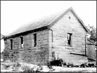 Balgowlah Public SchoolIn 1893/4 a new school house for 81 pupils was erected here on about two acres of land resumed from Andrew Hinchcliff's estate. It was built of local stone by James Booth of Pittwater for £260. It replaced an earlier school established by the Government in 1881, which had been housed in an existing weatherboard cottage. The area was still semi rural and relatively isolated. In 1936 land to the north was acquired for the present Seaforth Public School which opened in 1940. The original school building stood empty until 1944 when it was converted into a children's library and craft centre by a group of local women. In 1945 the Balgowlah/Seaforth Library was officially opened and receives an annual subsidy from Manly Council. In 1978, after libraries were established in public schools, membership was extended to adults. Today, the original old stone building is heritage listed and remains a monument to the community efforts that have sustained it.
Photograph courtesy: Manly, Warringah & Pittwater Historical Society
14. St Paul's Church, Seaforth
(on reverse of Balgowlah/Seaforth Library plaque)
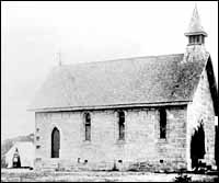 St Paul's Church, Seaforth
From 1843 Anglican worship on the peninsula was centred around St Thomas' Church at North Sydney. More parishes were established as the population grew. After 1859 residents of Middle Harbour, now Seaforth, attended Church of England services in Manly. As the population increased in the Middle Harbour area the need arose for a closer, more convenient place of worship. In 1871 parishioners began holding their own church services in a room in Peter Ellery's home overlooking the Spit. Ellery was a pioneer of the district who operated a ferry service across the Spit in the late 1840s. Donations were collected for the cost of acquiring land and constructing a church. Peter Ellery offered a piece of land and the foundation stone was laid in 1873. The church was designed in the Victorian gothic style by Alfred Cook and completed in 1875 and was known as St Paul's Middle Harbour. From 1906 this area was known as Seaforth. The present St Paul's Church, designed by Lloyd Wynn was officially opened by the Most Rev. H.R. Gough, Archbishop of Sydney on 30 April 1961.The original sandstone church, with a new tile roof, has been incorporated as a chapel and holds many memorials.
Photograph courtesy: Manly Art Gallery & Museum
15. Dalwood Home
21 Dalwood Avenue, Seaforth
 Dalwood Home, c1928In 1928, A.E. Dalwood donated his property to the Food for Babies Fund which cared for mothers and babies from disadvantaged families. In 1932 Dalwood Home was incorporated as a secondschedule public hospital and later brought under the control of Manly-Warringah Area Health Service. Since 1992, Dalwood Home has been the responsibility of Manly Hospital and its range of services has been expanded. Currently there is a family care centre, day care centre, assessment centre and school for country children. The principal building is heritage listed. The original sandstone building was erected as a family retreat by Theodore Gurney, a Professor of Mathematics at Sydney University. He named it Clavering after the village in Essex where his father had been vicar. After Gurney's return to England in 1902 the building lay vacant for many years. It was acquired by A.E. Dalwood who sold off the land surrounding this grand home in 1922. He retained the house and a small acreage around it. Theodore Gurney and A.E. Dalwood are remembered by Seaforth street names, Gurney Crescent, Clavering Road and Dalwood Avenue.
Dalwood Home, c1928
Photograph courtesy: Seaforth Public School and Manly Library
Top | Walks Menu | Visitor Info Menu
16. Federation
Federation Point, Commonwealth Parade
Sir Edmund Barton (1849-1920)
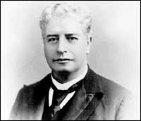 Sir Edmund BartonLocal resident and first Prime Minister of Australia Edmund Barton lived at Calahla (now called Whitehall) corner Woodland and White Streets, Balgowlah from 1888 to 1891, and then in James Street, Manly until 1893. He entered New South Wales Parliament 1879. In 1891 he succeeded Sir Henry Parkes as leader of the Federation Movement in New South Wales. In support of this cause Barton coined the phrase: There will be a nation for a continent and a continent for a nation. He became first Prime Minister of Australia from 1901 to 1903. Then he served as a judge in the first High Court until his death in 1920.
Sir Edmund Barton
Photograph courtesy: State Library of NSW
Commonwealth Parade
The road above was originally a walking track known locally as Lovers' Lane. Following a petition from a resident, Manly Council developed a road from West Esplanade towards North Harbour. It was completed in 1901 and named Commonwealth Parade to commemorate the inauguration of the Commonwealth of Australia on 1 January, 1901.
Federation Point
Named by Manly Council in 2001 to commemorate the centenary of the Federation of the Australian Colonies.
Heritage Plaques in Manly
Key to Plaque locations
- The Aboriginal Heritage of Manly East Esplanade Reserve
- Manly Cove 1856 / Henry Gilbert Smith Manly Cove, west side of Manly Wharf
- The Corso 1920s The Corso, outside Coles
- The Corso 1915 / Bards of Manly The Corso, Manly Beach end
- Marine Parade 1920s Marine Parade overlooking Manly Beach
- South Steyne c.1929 North Steyne, grassed area near Carlton Street
- Ivanhoe Park c.1930 Ivanhoe Park, near cnr Sydney & Pittwater Roads
- Fairlight House On Scenic Foreshore Walkway near Fairlight Beach
- Village of North Harbour North Harbour Reserve near Beach Street
- Dalley's Castle / Dalley Park In Gilbert Park near Tower Street
- Queenscliff Bridge / Manly Lagoon West side of Queenscliff Bridge in park
- Jenkins Road On Scenic Foreshore Walkway near King and Lauderdale Avenues
- Bridging the Spit Start of Scenic Foreshore Walkway in Avona Crescent
- Balgowlah-Seaforth Library / St Paul's Church Corner Frenchs Forest & Sydney Roads, Seaforth
- Dalwood House 21 Dalwood Avenue, Seaforth
- Federation Federation Point, Commonwealth Parade
This publication has been produced by Manly Council's Heritage Committee, 2002
Heritage Plaques in Manly ©2002 Manly Council Marine Parade 1920s: Courtesy Manly Art Gallery & Museum, Acknowledgements: Katherine Roberts & Christopher Parsons Map drawn by Renée Ezz. Photographs courtesy Manly Library & Manly Art Gallery and Museum. Produced by Manly Council’s Heritage Committee, 2002

 Mondo Mortgages
See also:
- Heart of Manly Heritage Walk
- Eastern Hill Heritage Walk
- Manly Heritage Plaques
- Manly to Spit Bridge Scenic Walkway
- Manly to Shelly Beach
- Fairfax Walk - North Head
- Barrenjoey Lighthouse
- From The Crown to the Sea
- Pittwater Bushwalking Tracks and Guide
- Walks Home
- Things to See and Do Home
- Visitor Information Home

Manly & Northern Beaches Information
Manly & Northern Beaches Businesses
- Business Search
- Business Classifieds
- Real Estate
- Education
- Wedding Services
- Functions & Conferences
- Community
- Health, Sport & Fitness
- Transport & Travel


Manly Australia Social Pages