


Manly Eastern Hill Heritage Walk Introduction
Firstly let us acknowledge and pay our respects to the traditional owners of this land, the Kayimai and Cannalgal people of this area. This walk will guide you through the Eastern Hill area of Manly, with the option of visiting the beaches on its fringes. This is a dynamic landscape, both built and natural, rich in a history of planting and building, creating and covering open spaces. Look for pointers to its past, and enjoy the multiplicity of its present. There are many tranquil places to stop and picnic on this varied walk. Possible picnic spots are designated by the symbol.
Eastern Hill Heritage Walk information and images: © Text: Virginia Macleod, © Printed & Online: Manly Council 2001, With thanks to the State Library of NSW, Manly Library, Pittwater Library and the Catholic Church for permission to reproduce historic photographs used within the Heritage Walk content.
 Cabbage Tree Bay ReserveThe full walk will take you two to three hours; allow time for picnicking as well.
It starts at East Esplanade and finishes at South Steyne.
It may also be completed in sections:
1. Little Manly Point, returning via Wood Street
2. From South Steyne to Shelly Beach and return (accessible to wheelchairs).
3. Follow the walk to Little Manly Point then proceed to Darley Road and St Patrick's College (this avoids steps at Collins Beach and shortens the walk by approximately 30 minutes).
There are toilets at Little Manly Beach, Shelly Beach and Fairy Bower.
Access notes
As the name Eastern Hill indicates, this is a fairly steep walk, and there are some steps. Only the section South Steyne to Shelly Beach and return is fully accessible to wheelchairs.
The Eastern Hill area
When was the name Eastern Hill first used, and who decided upon this rather literal label for the sloping and often steep area to the east of the heart of Manly, fringed by beaches? History books provide no answer. But they do tell us of the area's first inhabitants, and how the hill became covered in houses, suburbs and streets. Perhaps, once you have completed this walk, you may have some answers yourself.
The first inhabitants
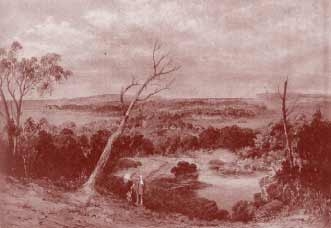 Sydney Harbour from Queenscliff by Conrad Martens
The first inhabitants of the Manly area were the Aboriginal people known as the Kayimai. They lived as hunter-gatherers, roaming according to the seasonal availability of food and trading with other clans. They moved around, making shelter as needed from branches and fronds or using the many sandstone caves in the area. After European settlement at Sydney, 100 acres of land were granted in 1809 to Richard Cheers, a butcher. The grant extended east from present-day Ashburner Street to the grounds of St Patrick's College. Together with a 30-acre grant to Gilbert Baker, this land was known as Cheers Farm. D'Arcy Wentworth was the next owner of this grant, though it is unclear how the land passed to him. He died in 1827, leaving it to his two-year-old daughter, Katherine. All of the land in this estate was restricted and could not be subdivided or sold. It was eventually released by a special Act of Parliament, the Bassett-Darley Estate Act, in 1877. It was subdivided and auctioned from April 1877 onwards and gradually developed into the residential suburb it is today, fringed with beaches.
Top | Walks Menu | Visitor Info Menu
Starting the walk
The full walk starts at East Esplanade, off Ashburner Street. The white broken column monument, telling of a tragic lifesaving attempt, signals your starting point.
At the eastern corner of East Esplanade, steps ascend towards Osborne Street. At their base is a vast Moreton Bay Fig tree, over a hundred years old. This species was originally recommended for street planting throughout Sydney by Charles Moore, the Director of Sydney Botanic Gardens. It was later rejected as unsuitably large for streets, but its wide canopy has provided elegance and shade in many open spaces, and some fine examples will be seen on this walk. In the 1960s and 1970s, tables with inlaid chessboards sheltered under this tree, and men taught children cards and chess on their way home from school.
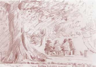 The Euchre Players 1959
The Euchre Players 1959 - Sketch by Pat Macmillan nee Penfold
History on the harbour's edge
Follow the path southwards along the edge of the harbour, past the next set of steps.
Along this waterside strip is an area of concentrated nautical history. The first building is the Manly Cove Launch Club, established in 1937. Next to it stands the heritage-listed Manly Rowing and Sailing Club Boatshed. Established in 1875, this was one of the earliest waterside clubs in NSW. Rowing was a popular sport then.
The shed is about 19 metres long, built to accommodate 8-oar shells or skiffs. In 1885 a second shed was added to house canoes and sailing boats, as well as boats that were raced for wagers. The first Manly regatta was initiated by the club in 1890. The club also took a prominent part in the Venetian carnivals. These were major events with parades, fireworks and a water pageant. They were called `Venetian' because they were reminiscent of water-based life in Venice.
You will see Manly Yacht Club straight ahead. This is the site of the former Gentlemen's Baths, 'the largest and most efficiently equipped gentlemen's swimming baths in the state', opened in 1892. In October 1926, a new Olympic pool with a grandstand to seat 1400 people was opened at a cost of £11,000. Boy Charlton, returned 1924 Olympic swimming champion, was present. This occasion was also the subject of the first broadcast on 2BL radio.
The photograph on page 8 illustrates its structure when it was opened. The Baths suffered severe storm damage in May 1974 and were closed in April 1976. The Harbord Diggers swimming club held a ceremony with special guests Sir Robert Askin and Fitz Lough, who had swum at the baths for seventy years. At the last race a wreath was floated in the pool. It was said that since the first race had been held in 1890 the pool had `seen more Olympic champions in action than any other swimming centre in this country.' Early in 1977 the Manly Yacht Club submitted plans to convert the remaining buildings for boat storage, and has been in residence ever since. The jetty you see today formed one side of the Olympic Pool.
Top | Walks Menu | Visitor Info Menu
Choosing a manager
There was some controversy surrounding the appointment of the first manager of the new Baths. Some aldermen felt that preference should be given to soldiers returned from the First World War, but Alderman Quirk replied that `the rising generation would never have a chance' if this were the case, and the position was given to Dick Eve, Olympic champion diver. His father had been manager of the earlier Baths here.
Olympic Pool 1927
[Olympic Pool: swimmers Charlton vs Takaishi (Japan), 1927]
Houses on East Esplanade
Backtrack a few metres now, and climb the shallow steps to the street, East Esplanade.
As you stand at the top of the steps, you will see ahead of you, across the road, several houses dating from about 1890, which can be identified in the photograph of the pool.
Several villas were built in the late nineteenth century on Eastern Hill. Some of these homes still stand today, although their expansive gardens and lawns have now been covered by houses.
From your position at the top of the steps, turn right and proceed along East Esplanade to the corner of Stuart Street.
Wharf and ferry
At the water's edge, in the reserve on your right, is the 16 Foot Skiff Club, formed in 1923 as the Manly Sailing Club. Brightside Wharf used to stand just to the south of the clubhouse; for a while the ferry to Manly called here. The ferry was advertised as an attractive feature for potential land purchasers on this side of Eastern Hill.
Gocher Court
The five-storey brick building at the corner here, Gocher Court, was built in 1952 for the Housing Commission. It provided much-needed accommodation, as housing was in very short supply after the Second World War. This photograph shows the opening. This marked the start of the spread of high-rise units, which were to reach ever higher and blight Manly. However, in 1969 Manly Council attempted to limit the height of buildings and under the Manly Planning Scheme further restrictions were introduced in 1986.
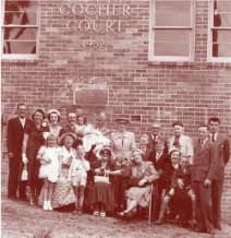 Gocher Court opening 1952Walk up Stuart Street to the junction with Addison Road, the second road to your right.
Addison Road trees
If you look to the left along this road, you will see a fine example of municipal planting, an avenue first planted in 1882. Norfolk Island Pines are mixed with Port Jackson Fig trees, which were preferred to Moreton Bay Fig trees because they were smaller. These trees have provided welcome shade in the heat of summer for over a hundred years.
Now turn right into Addison Road, and continue to the end of this road.
Addison Road architecture
Here are some excellent examples of different styles and periods of architecture. Note the variations in size of blocks of land in this street; in the last half of the 20th century, many blocks were subdivided to make room for additional housing. Can you recognise the following house styles - Italianate, Victorian Villa, Federation, Interwar Spanish Mission, Old English, Californian Bungalow, Post-war International, Late Twentieth Century, and Post-modern?
Top | Walks Menu | Visitor Info Menu
Peace Park at Manly Point
Continue to the park at the very end of the street.
Peace Park, located here, is one of several world-wide spots where signs proclaim the wish for peace throughout the world. Organised by a Japanese peace movement, the stone near the road was dedicated in 1986. The plaque on the stone and others inspired by the same movement, have the following wording: "World peace begins in the hearts and minds of each individual - may we each seek harmony and peace in our daily lives. "
View the harbour from the park, and look to the left for Little Manly Beach and Collins Flat, which you can visit later on this walk.
Leave the park, returning on this side of the road to the intersection with Stuart Street. Turn right down Stuart Street to find Little Manly Beach. Turn right into Craig Avenue for Little Manly Beach.
The timber house on the corner of Craig Avenue and Stuart Street was the home of James Farrell, fisherman, from 1898. Walking down Craig Avenue towards the beach, you will see a grassed area to the left of the boat ramp. Here Farrell constructed a boatshed in 1916.
Note the stone bench on the grass, with the inscription: In memory of the Farrell family, skilled and brave boatmen and pioneers of Little Manly, 1981.
Little Manly Beach
This beach is a popular family beach and has long been a place of recreation for residents.
Imagine a summer's day in the 1940s. The beach is very busy. Many people are hiring boats and fishing for kingfish and leatherjackets, and for blackfish near Collins Flat. Boating is very popular, and many of the surf clubs keep their boats here for training. In 1976 the house and boatshed were sold to Manly Council. The boatshed was demolished.
The enclosed pool at the eastern end of the beach was constructed in 1880. It was known as the Crystal Baths. A keen eye can detect the faded word `BATHS' on the rock face beside the pool. The original fencing was timber rather than metal. See the tiny pools in the rocks at the edge of the beach. Do you think these were formed naturally? Note that a shed once stood here. It was supported on timber poles.
Top | Walks Menu | Visitor Info Menu
Storms ahead
As it faces south, this beach is exposed to storms. In June 1974, two weeks after the storm that damaged the pool in Manly Cove, a ship rolled coming through the Heads, and lost all of her deck cargo of oregon. The 12-metre (40-ft) timber lengths floated into Little Manly Beach, where they were piled up and later auctioned.
Take the steps that begin near the enclosed pool, and continue south-east. The path that joins the steps will take you to Little Manly Point.
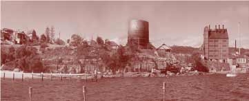 Gasworks at Little Manly Point
Little Manly Point - Gasworks
Little Manly Point, once an industrial site, is now a park. The Manly Gas Company's works originally produced gas here for anyone within five miles (8 km) of Manly Post Office. The company purchased the land for £600 and paid half the cost of making good the road from the bottom of Stuart Street to Little Manly Point. Gas was used for lighting from 1884, and by 1923 there were 329 lights covering 30 miles (50 km) of streets. Lamplighters climbed ladders to light each lamp with a taper, for which they were paid 25 shillings a week. From 1926 gas was also supplied to Warringah as far as Collaroy and Narrabeen, and several years later reached as far as Newport. The walk around the park was opened in 1992. The plaques show how the gasworks operated.
Coal was brought by ship to the Point and offloaded from Spring Cove at the jetty there. Apart from producing gas the works had by-products: coke, which was sold as a fuel and used by ferries among others; tar, which was used for road surfacing; and ammonia, which was punted away, distilled and sold as long as it was economic to do so.
When the gasworks were opened in 1883, the Point was isolated from the rest of Manly. Gradually, however, housing increased in the area, and some employees later moved, to live close by in Stuart Street. The gasworks employed about 40 men. Some played quoits at lunchtime, and at one time cricket nets were used on the lower area beside Little Manly Beach. The company was considered progressive, with all the most up-to-date equipment by the time it reached its heyday in 1938.
The showroom in Manly even gave weekly lectures on cooking. The switch from cooking with fuel stove to a gas stove which gave instant heat, with no cleaning of ashes, was an important change for many women during the first half of the twentieth century.
Top | Walks Menu | Visitor Info Menu
End of an era
However, as an increasing population began to need more gas, the site became too small. The works closed in 1964, and were sold to the NSW government in 1970. The buildings were demolished in 1971, but the site lay otherwise untouched for many years. A new park was created here, with a quantity of toxic waste being removed or sealed in the ground, and the whole area was landscaped and planted. Since the park was opened in 1992, it has become a popular recreation area.
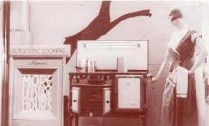 Advertisement for gas cookers
Advertisement for gas cookers, Gas Co. showroom, Sydney Manly 1935
Spring Cove
Spring Cove lies to the east of this park. In 1975 a 12-metre strip of foreshore, part of St Patrick's Estate, was made available for a public walkway. The buildings of the Quarantine Station are visible on its further shore, as is the Australian Institute of Police Management, site of a hospital for seamen during World War I. From 1832 ships would anchor in Spring Cove if there was anyone on board with a contagious or infectious disease. From 1837 accommodation was established on shore, and new arrivals were isolated there. From 1838 signal flags were flown at Cannae Point to warn of the dangers of approaching the Quarantine Station, and a yellow flag ordered ships with contagious passengers to take them to be quarantined. The signal mast, which was probably erected in 1853-4, has been repaired from time to time, most recently after lightning damage in 1986.
Plague!
The Station was also used to isolate Sydney residents. In 1900 there was an outbreak of bubonic plague, and cases from both the city and Manly were quarantined. It was last used for Vietnamese refugees, and was closed in 1984 and given to the state government. It became part of the Sydney Harbour National Park, administered by the National Parks and Wildlife Services. The Quarantine Station, a unique element of Australia's heritage, was left almost untouched for most of the twentieth century.
For a longer walk through bushland and a secluded beach, continue from the end of Stuart Street down the path to the left to Collins Beach. There are some steep steps to and from Collins Beach, and the path may be muddy.
Otherwise go to `Darley Road'. Or return via Wood Street.
Top | Walks Menu | Visitor Info Menu
Collins Beach, Aboriginal People
 Collins Beach todayThe seclusion of this beach makes it possible to recall the life of the Aboriginal people before European contact. The mainstay of their diet was fish, and they were highly skilled at fishing in a variety of ways. They fished from the rocks, in the water, while swimming and from canoes; women used lines and men spears, with several points. Men made spears from the spikes of grass trees, hardened in the fire and tipped with bone. Both men and women used fine lines made of fibrous bark from Cabbage Tree palms or wattles, soaked in water for strength. Hooks were commonly made from shell or bone. Bait, other fish, was usually cast on the water. There was often a small fire aboard the canoe for cooking the fish. Children went fishing too, and had smaller spears suited to their size. Groups would gather on the shore to feast if a whale was stranded. In some other places along the harbour's edge, Aboriginal people engraved the outlines of animals and people on the rock. Some hand stencils are also still present.
Little visible remains here today of Aboriginal culture, except the occasional midden - a collection of shells and fish bones. But Aboriginal people still lived at Spring Cove from time to time, the last as recently as the 1950s.
To continue the walk, cross the beach and climb the track to the left of the waterfall. Follow the path from here to the right to the Australian Institute of Police Management.
Parkhill Cottage
Pass the sign to Parkhill Cottage, built in 1921 as the residence for the medical officer attached to the Quarantine Station. It was later occupied by the Department of Defence, and more recently as a day centre for Manly Hospital.
Turn left at the T-junction at the top of the hill.
Top | Walks Menu | Visitor Info Menu
North Head
During World War I and World War II, North Head was an important strategic point. From 1936 defences were established, including a 9.2 inch gun. From 1945 to 1997 the Royal Artillery School was based here. It was involved with the Manly community, especially on official occasions, such as the annual Anzac Day ceremony at Manly's Cenotaph in the Corso. From 1901 walls were built on both sides of the road, to separate the Quarantine Station from St Patrick's College. Walk beside the archway, which has changed in function. On its original site, it formed the gateway to the Quarantine Station. In 1921 new walls were built to separate the new hospital from the Quarantine Station. The gateway was moved as part of an employment project during the Depression. The archway was renamed to commemorate the opening of Parkhill, Reserve by the Hon. A. Parkhill MP in 1933.
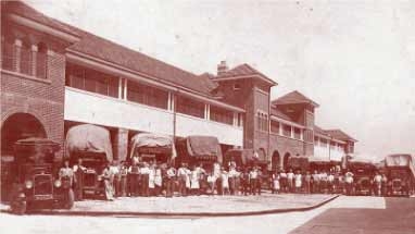 Manly Hospital during moving in process 27 October 1931Continue until you reach Manly Hospital.
Manly Hospital
The first hospital was opened in 1896, on the corner of Raglan Street and Quinton Road adjacent to Ivanhoe Park. This hospital treated a variety of conditions, but enteric diseases in 27 October 1931 particular, as the incidence was higher in Manly than many other parts of Sydney because of poor sanitary conditions. The first hospital was soon too small. In October 1917, twelve acres of land were granted at North Head for a new hospital, which was not built until 1927. This hospital could not be used until 1931, when nurses' accommodation was completed, and patients and nurses could move in together.
This hospital has always been strongly supported by the community, and half of the money for building it was raised locally. Fund-raising events, in particular the Venetian Carnivals, have continued to support further needs.
Continue down the left side of Darley Road to the Archbishop's Residence.
Darley Road
If you are not taking the Collins Beach route, go back down Stuart Street towards Little Manly Cove, and turn right at Marshall Street, to climb the hill to Darley Road.
In 1885 there were houses in Addison and Darley roads, described as `wretched little cottages with which some greedy wretch defiled the landscape'. Would you say that this is still the case today?
At Darley Road, turn right, and you will see the Archbishop's Residence on the right-hand side of the road, next to St Paul's College.
Top | Walks Menu | Visitor Info Menu
The Archbishop's Residence
In the 1850s the NSW government was anxious to see both Anglican and Catholic archbishops properly housed. After deliberation over various sites, 60 acres of land at Manly were promised to the Catholic Church in 1859. The grant was finally signed in 1879. The Archbishop's residence, commonly referred to as the Cardinal's Palace, was built in the domestic Gothic style and finished in 1886. It cost £10,000, a considerable sum in those days. The first cardinal to live here was Cardinal Moran, whose coat of arms can be seen on the wall of the building. There is also a private chapel in the building, on the first floor. Cardinal Moran died here in 1911 but was buried in St Mary's Cathedral, Sydney. There are some magnificent trees in the grounds, which extend to the foreshore at Collins Beach. St Paul's College, a boys' high school, opened in 1929 and occupies part of the grounds.
Cross the road to the main entrance to St Patrick's College. The International College of Tourism and Hotel Management is the current lessee of the buildings. Through the gates can be seen the back of the Cerretti Chapel.
The Cerretti Chapel, designed by the same firm of architects as the college, was opened on 18 November 1935. It is named after a visiting cardinal, the first Apostolic delegate in Australia. Before it was built, there was no appropriate chapel building for the students and staff of the college.
Walk a few metres down Darley Road to the lower gates, through which can be seen.
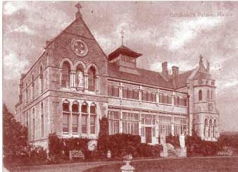 The Archbishop's Residence
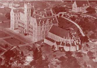
St Patrick's College
It was Cardinal Moran's vision to establish a college to provide Australia with locally trained Catholic priests. It was appropriately isolated, as the novices were expected to lead a secluded life. They were only allowed out for a walk once a week, together in file, and were not allowed to talk to anyone (Manly today might not be considered as suitable for those requiring extreme seclusion!).
The college building was designed by Sydney architects Sheerin & Hennessy, and is similar to their design for St Joseph's College in Hunters Hill; the style blends Gothic and Romanesque. It was constructed in sandstone, originally quarried locally but later shipped from Pyrmont. A city of tents accommodated the 200 workers during the three years it took to complete the building. W. B. Dalley, a local Catholic, referred to the rising college as `that imperial building'. There was, however, some local opposition to the building by non-Catholic members of Manly Council.
 St Paticks Estate 1947
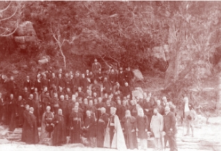
Laying the cornerstone
On 19 November 1885, Cardinal Moran laid the cornerstone, using a silver trowel and mallet, and blessed the building. It was a magnificent occasion. The cardinal in red robes and bishops in purple came from Woolloomooloo in a special ferry, which landed them on the harbour side of the church property. After the ceremony everyone descended to Shelly Beach for lunch in a marquee.
A little over three years later, at the official opening on January 1889, Cardinal Moran presided in white and gold robes. He took a personal interest in the development of the college. His initials, PFM, and his motto, `Omnia omnibus', are carved at the base of the central tower. For many years this splendour associated with the college was renewed in annual Corpus Christi processions, when crowds of as many as 75,000 lined Darley Road to the college.
 St Patrick's College 19 November 1885The College tower afforded a signaller's lookout during World War I. It was at this time that the grounds were divided by the extension of Darley Road onto North Head for strategic reasons. The walls that flank the road were a condition of this intrusion into the reclusive life of the College.
Continue down Darley Road and turn right into Vivian Street. Pause at the corner of Fairy Bower Road.
Here is Bear Cottage, opened in 2001 to provide respite for sick children and their families.
Walk down Fairy Bower Road through the lane at the eastern end. Go down the steps and turn right in to Addison Road. Turn right at Reddall Street, and St Patrick's College will be visible again.
After laying the foundation stone of St Patrick's College, 19 November 1885
Top | Walks Menu | Visitor Info Menu
Landmark
Moran House, St Patrick's College, remains a landmark today, even though the seminary left in 1995 and the building was leased to the International College of Tourism and Hotel Management. The College and the Cerretti Chapel are used for functions and are open to the public from time to time.
The grounds are an important part of the whole college. Some magnificent trees, now over a hundred years old, are still standing.
Follow Reddall Street down the hill and turn right on Bower Street.
In 1914 an Act of Parliament permitted the Catholic Church to subdivide 21 acres of land above Shelly Beach and Fairy Bower. The church leased the land to meet the cost of upkeep of the College. The properties on the church land have limited leases, and will expire after 99 years. Agreements have been made to renew some of the leases.
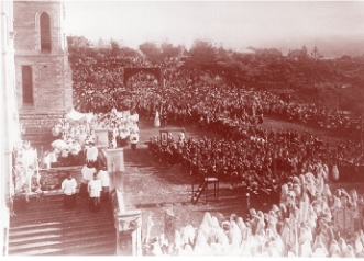 Corpus Christi Procession
Walk along Bower Street to the giant pair of Moreton Bay figs on a grassed reserve. Cross the grass to the steps beginning on your left, which lead down to the beach.
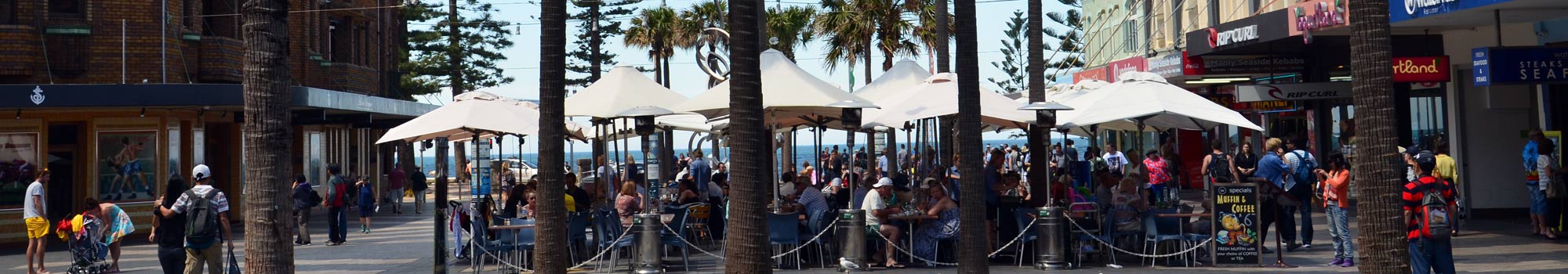
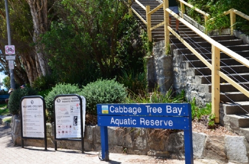
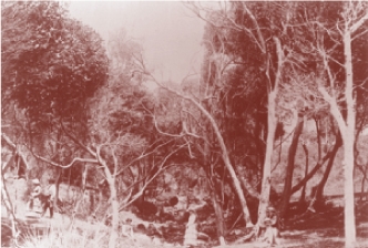
This route was described at the time of the dedication of St Patrick's College in 1885 as an `alpine path'. In 1990 the gully, which had become a refuse dump, was cleared and regenerated by Manly Rotary Club, Manly Council and two local schools. First eucalypts were planted to create a canopy, and then other plants suited to a rainforest area were added. Planting also included Cabbage Tree palms. The bay below and Manly Ocean Beach were once named after this tree. Some people still refer to the area as Cabbage Tree Bay. The trunks of the palm were easily cut for building and fences. The leaves were used for thatch and hats, and the pith was fed to pigs.
At the foot of the hill, you will arrive at Shelly Beach.
Shelly Beach
This beach is named for the enormous quantity of shells that used to be found here. In the 1920s the tide regularly deposited shells. By 1933 it was reported that hundreds of shells had been taken from the beach. Now few remain.
This was a popular beach for fishing boats to be hauled up on, and for boat owners for drying and repairing their nets. Look on the headland on the far side on the beach for the remains of a jetty, a winch, boat rails and a lookout tower for spotting shoals of fish.
Top | Walks Menu | Visitor Info Menu
Sly family
 Sly family fishing near the Quarantine StationThe Sly family kept fishing boats here from 1888, and in 1903 patrolled with their boat, demonstrating surf rescue methods. They were closely associated with the early surf life-saving movement in Manly. In 1936 G. J. Sly found an extremely rare vampire octopus washed up here, one of only ten sighted throughout the world and the only one ever found in Australia. It was about 1.25 metres across and pink in colour, and it ended its life ignominiously as bait.
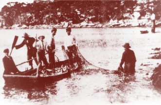
Fishing in Cabbage Tree Bay
Cabbage Tree Bay was once an important commercial fishing area in NSW. Up to fifty years ago, huge schools of kingfish, salmon and tuna were netted here. The Bay experienced a decline in fish population during the second half of the twentieth century. Now it is only occasionally netted commercially. However, in 1998 the Ministry for Fisheries launched a marine study conducted by the University of Sydney which found a rich diversity of fish, including four protected species and the blue groper.
Beach kiosk
For many years refreshment has been provided to visitors to the beach. The present stone kiosk was originally a tearoom when it was built in 1923. In the 1920s dances were held here. The sessions were organised by committees, with names such as `Bluebirds' or `Gumnuts', who decided who was suitable to attend.
If you wish, you can cross the beach and walk up the steps between the trees to circle the headland. Back on the beach, turn north towards Manly and walk along Marine Parade.
Along the shore to Fairy Bower In 1859 it was proposed to leave Shelly Beach and the land along the shore as far as Fairy Bower for the public to enjoy. However, John Robertson, Secretary for Lands, was keen to exclude the public, believing that the church grant should form a buffer between the public and the Quarantine Station. There was considerable objection to the exclusion of the public by 1885, but it was not until 1898 that Shelly Beach and the ocean foreshore were returned to the people at Manly Council's request, as this was such a popular recreation place.
Twenty-two acres of land from the Quarantine Station were added to St Patrick's College in exchange for eight acres of foreshore and headland at Shelly Beach. A sewer was laid along the foreshore to discharge the other side of the headland at Shelly Beach. Marine Parade was built over it as a walkway. Fairy Bower There used to be many wildflowers in this area. Francis Myers, who described the delights of Manly in 1885, said that the fencing of the land belonging to St Patrick's College protected a vast area of wildflowers. Myers also described Fairy Bower and Shelly Beach as pleasing picnic spots, with `never failing supplies of water, firewood always obtainable and delightful shade'.
In 1858, C. F. Hemington leased eight acres at Fairy Bower and advertised his place, reached by steps from the beach, with refreshment tents and tables and seats. By the end of the year, patronage had greatly increased, and a 50-gallon copper provided tea and coffee. Music and dancing were also organised.
Top | Walks Menu | Visitor Info Menu
Ferry service
For a short while in the early 1860s, there was a separate ferry service from Sydney to Little Manly. From there visitors could enjoy a shaded twelve-minute walk direct to Fairy Bower. This service was advertised as avoiding the noise of Manly. There was keen rivalry between ferry services, vigorously expressed in the press at the time.
 Fairy Bower 1890's
Queen's birthday celebration
In 1861, races were held at Fairy Bower to celebrate the Queen's birthday. There were sack and wheelbarrow races, as well as a running race with a prize of £25 (£1 could purchase 40 ferry tickets, at sixpence each). Full meals, sandwiches, oysters, tea, coffee, wines and spirits were all served. The day culminated in a fireworks display.
Business must have been precarious at the time: a twelve-room hotel with balcony in this area was offered for sale in 1863, and again in 1865 and 1868. In April 1868 the hotel was destroyed by fire.
A tradition of entertainment
Dancing was a very popular pastime in Manly during the first half of the century, and there was a dance hall at Fairy Bower in 1914. In 1927 Mrs Greenwood of the Fairy Bower Casino Café advertised high-class accommodation, and today there is still a café. Fairy Bower's tradition of entertainment continues.
Smallest swimming pool
The swimming pool was built by local residents in 1929. This is the smallest pool in Sydney, apart from those built especially for children. It remains almost unaltered from its original state. It has not always been a viable pool, and its condition has varied. For example, in 1961 the fire brigade had to be called out to pump water into the dry pool.
Continue along Marine Parade to Manly Ocean Beach.
Along the Parade is a fine sculpture, Shell and Wave, representing aspects of the sea and time. In 1986 a threatening overhanging boulder was cut away from the rock face. Cliff Axelsen and a group of students from Seaforth TAFE carved this work from the boulder, and it was dedicated to all of Manly's Surf Life Savers.
Top | Walks Menu | Visitor Info Menu
Manly Ocean Beach
To hinder enemy landings during World War II, rolls of barbed wire were laid along the beaches. The remains of tank-traps, tetrahedrons made from concrete, are still buried under the sand here. Look for three weathered specimens near the walkway just after Bower Lane.
Proceed to the Manly Life Saving Club at the junction of Marine Parade and South Steyne
 Childs Play 1940
Childs Play near tetrahedrons late 1940s
Can you find the plaque commemorating the sewerage works of 1898? Look behind the club, on the rock face at the corner of Ashburner Street.
South Steyne
Offshore of South Steyne is a popular surfing spot. In 1936 tragedy struck when a teenage boy was taken by a shark while out swimming with two friends. The conditions were typical for a shark attack: the sky was overcast, and it was late afternoon. In the 1930s and 1940s, sharks could often be seen in the water. Sharks netted by local fishermen were displayed in a shed at Fairy Bower for a small fee, and the proceeds went to the Surf Club.
Sydney's garbage was regularly dumped in the sea until the 1930s, and sewage was discharged at the beach. The end of these practices, and the introduction of the practice of netting the beaches, mean that sharks are rarely seen now in this area.
From South Steyne, proceed to Manly's central business district, in the vicinity of The Corso. Here you can explore Manly further, or relax.
Top | Walks Menu | Visitor Info Menu
More about Manly
We hope this walk has given you a taste of the history of Manly, and a chance to discover the layers of history in the landscape. If you enjoyed it, you might like to do other walks in the area. This is the second in our booklet series; the first is the Heart of Manly Heritage Walk.
Further information can be obtained at Manly Library's Local Studies section in Market Place, and at Manly Art Gallery in West Esplanade.
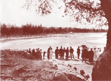 View of Manly Beach from Marine Parade 1920s
We also recommend visiting the Q Station (former North Head Quarantine Station) and the North Head Lookout.
Dateline from the text
1810 - First grant of the Eastern Hill land, to Richard Cheers.
1827 - Land passed to Wentworth's daughter, Katherine.
1859 - Eastern Hill area subdivided and auctioned from April onwards; gradually developed into the residential suburb it is today. 60 acres of land at Manly promised to the Catholic Church.
1860 - Separate ferry service established from Sydney to Little Manly.
1883 - Races held at Fairy Bower to celebrate the Queen's birthday.
1884 - Gas lighting comes to Manly.
1885 - Exclusion of the public from Shelly Beach.
1889 - 23 January: official opening of St Patrick's College.
1896 - First Manly Hospital opened.
1898 - Shelly Beach and ocean foreshore returned to the people.
1923 - Building of Cabbage Tree Bay beach kiosk near the fishing huts and sheds, offering food and refreshment to the present day.
1926 - In October: new Olympic Pool opened at the Gentlemen's Baths; first broadcast on 2BL radio on this occasion.
1935 - In November: the Cerretti Chapel opened and named after a visiting cardinal, the first Apostolic delegate to visit Australia.
1936 - G. J. Sly finds an extremely rare vampire octopus. Washed up on Shelly Beach, it was one of only ten ever seen in the world, and the only one ever found in Australia.
1936 - Teenage boy taken by a shark at South Steyne.
1952 - Gocher Court built for the Housing Commission, to provide much-needed accommodation after the Second World War; the first example of high-rise units in Manly.
1964 - Manly Gas Company's gasworks closed.
1969 - Manly Council attempted to limit the height of buildings.
1970 - Manly Gasworks sold to the NSW government.
1974 - In May: Manly Baths suffer severe storm damage. Two weeks after the storm, a ship rolls coming through the Heads and loses all her deck cargo of oregon.
1976 - In April: Manly Baths closed.
1986 - Under the Manly Planning Scheme, further restrictions on the height of buildings introduced.
1998 - Marine study by the Ministry for Fisheries finds a rich diversity of fish, including four protected species and the blue groper in Cabbage Tree Bay.
Eastern Hill Heritage Walk information and images:
© Text: Virginia Macleod,
© Printed & Online: Manly Council 2001,
With thanks to the State Library of NSW, Manly Library, Pittwater Library and the Catholic Church for permission to reproduce historic photographs used within the Heritage Walk content.

 Affordable Tree Services Northern Beaches
See also:
- Heart of Manly Heritage Walk
- Eastern Hill Heritage Walk
- Manly Heritage Plaques
- Manly to Spit Bridge Scenic Walkway
- Manly to Shelly Beach
- Fairfax Walk - North Head
- Barrenjoey Lighthouse
- From The Crown to the Sea
- Pittwater Bushwalking Tracks and Guide
- Walks Home
- Things to See and Do Home
- Visitor Information Home

Manly & Northern Beaches Information
Manly & Northern Beaches Businesses
- Business Search
- Business Classifieds
- Real Estate
- Education
- Wedding Services
- Functions & Conferences
- Community
- Health, Sport & Fitness
- Transport & Travel


Manly Australia Social Pages